The Mounties to the rescue – Baby on the run
Friday, November 12th, 2010Cape Spear to Whithbourne.
Nov 9-10.
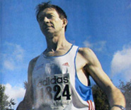
I left Cape Spear, my North American starting point as it is the most eastern point on the continent. That meant I had connected up Dunquin Co. Kerry as Ireland’s most western point to the Newfoundland tourist spot.
I am very grateful for the help of my local contact Sandy Pike who was simply amazing despite having exams at noon she still dropped me to my start. Once again I ran into and out of the Atlantic.
Ta Sandy, she ran a little with me then had to rush off to studies.
Half an hour later NTV or Newfoundland TV pulled up and I gave a tv interview for their 6pm news magazine show. I never saw it but Sandy texted me to say it was a good one. I must check their website. I gave Chariot Carriers a major plug as they are from here.
I ran on alone, clicking in around 45.2km for day 1.
I camping behind the commercial vehicle weigh scale station, about 30km from St. Johns.
It was a cold and wet night but next morning I was greeted by the officer who allowed me to make coffee and warm up in the weigh station office. I tried weighing Nirvana, too light to weigh, I wish!
Got pulled over by the Royal Canadian Mounted Police, or The Mounties! Not on a horse but in a cop car. He said someone reported a lunatic running down the highway with a baby!!
He even looked inside my Chariot jogging stroller!
At 1pm a man in a construction site parking lot told me Whitbourne was just 10km away.
I got a huge amounts of hoots and toots, guess its from the tv interview.
Later that day a man called Roy gave me 20 dollars for the charity.
This area reminds me a lot of Ireland, especially the Dingle pensinula. Beautiful little coves, forestry and long rolling hills.
Dunquin could easily twin with Cape Spear.
I rolled into Whitbourne at 5pm. So much for 10 kilometers.
Cindy and Ann from Montys Place truck stop where I camped behind gave me 15 dollars for AWARE.
Please check out the donate button on the site for my charity, AWARE.
Am told the area is called the Irish loop because viewed from the sky it resembles a shamrock.
Thinking its best to stick to secure places and areas I can get refreshed I am making for Service stations as there is not much in between. It can get cold putting up my tent around the back of the truck stop so I can come in for warmth whenever I like. Also great to end the day with a dinner and start with a breakfast. I usually hustle very hard introducing myself saying a world runner appreciates generous portions! Learning fast on my feet, I guess.
Because I make for the truck stops meant day 2 was a very long haul 9-5pm and 59km to Whitbourne. I was tired starting today but managed to get in another 56km to a restaurant that closes in a few mins, so that’s why this is so hastily written, sorry. I am in Arnolds cove after a 9 hour day. The truth is today was more than 60 as I ignored a locals shortcut and followed the highway route, so 56 it will be.
It gets dark around 5pm here -3 hours G.M.T. Newfoundland time zone.
Tomorrow I will be in Clarenville just 45 away and starting to sound like an easy day! Monday the first major town, Gander about another 147.
So far in Newfoundland I have run circa 160km in 3 days. I dont really want to do these distances at the start of the world jog but circumstances dictate.
13 Road days = 536.7km not counting Dublin marathon.

The World Jog continues from Dunquin, Co. Kerry, the most western place in Ireland! Out of the Atlantic Ocean and onto the most eastern spot in North America, Cape Spear,Newfoundland,Canada.

And the run through the Americas all the way to Tierra del Fuego has finally begun!

Many thanks to Sandy Pike for helping with the start of the North American leg. My Newfoundland leg of the World Jog is dedicated to a great degree examination result for Sandy!

Interviewed by Newfoundland Television station NTV just outside Cape Spear.


A long way to go in Newfoundland. Port aux Basques is where I get my ferry to North Sydney,Nova Scotia, sometime early December.

Down the hill from Cape Spear my friends welcome me back to St. John's.

Out into the great wide open.

The Avalon peninsula kinda reminds me of the Dingle peninsula, but they do call this area the Irish loop, looks like a shamrock from the sky.
![]()